disasterGIS
Disasters can significantly affect human health and seriously disrupt the functioning of society. They cause widespread human, material, or environmental losses that exceed local capacity to respond, and call for external assistance. These events can be categorized as natural, human-induced, and complex.
- A Primer for Understanding the Principles and Practices of Disaster Surveillance in the United States
disasterGIS is an imagined field of research I’m exploring about the tensions that are entangled in GIS technology. Geographic Information Systems are increasingly used to respond to disasters - open source datasets and volunteer community groups can use the technology to map damaged infrastructure, or areas where supplies are most requred - like Humanitarian OpenStreetMap Team (HOT). The anti-eviction mapping project is another example of GIS as a source of counter mapping technology.
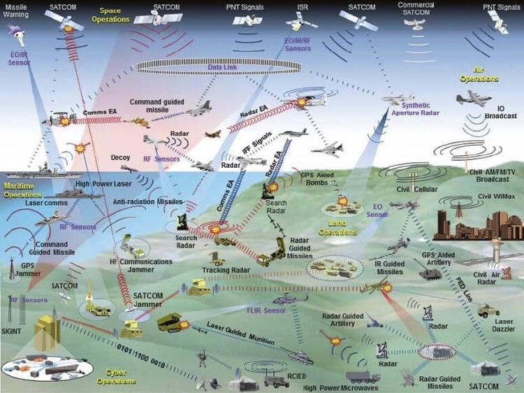
GIS is heavily involved and influenced by defence contracts - often spatial intelligence companies both provide military intelligence through their satellite networks, aiding in drone/air strikes, territorial surveillance or strategic planning that itself contributes to human-induced disaster. These same companies then often provide satellite imagery for free for relief efforts.
The role of GIS and geographic data science is haunted by it’s extractive and exploitative origins, it’s a core technology for modern multi-domain military operations, funding is priortised to spatial intelligence companies that aid in these purposes. disasterGIS could be a field to study community owned GIS infrastructure and to create frameworks on how collectives/communities can respond to disasters whilst operating in the contradictory, commercially dominated environment of spatial intelligence technology.
- Tags:
- Writing